
Watershed Report Card
What is a watershed report card?
The GRCA collects data about natural areas and measures water quality to better understand the health of the Grand River watershed.
Report cards share information about watershed health in a familiar format. They are simple tools that help us:
- Benchmark conditions
- Identify issues and develop watershed programs
- Inform decision makers
- Connect people with the environment
To accomplish this, we use our own data along with data from provincial, federal, and local partnerships. Conservation Ontario sets the guidelines for report card grades.
Grades are simple indicators of conditions for broad areas. While grades can help compare different areas, they don't capture local conditions, trends, or the root causes of the grades. Most indicators of watershed health change very slowly over time.
Our report card highlights aspects of:
- How the GRCA works to improve watershed health
- Groundwater quality
- Surface water quality
- Forest conditions
- Wetland conditions
- Next steps
Our State of Water Resources and Natural Heritage Characterization reports tell a more complete story of our watershed's health.
Improving watershed health
Improving the health of the watershed is a priority of GRCA’s Strategic Plan. The main ways the GRCA works to improve watershed health include:
- Supporting municipalities in optimizing wastewater treatment plant operations to improve the quality of the treated effluent discharged to the river.
- Delivering stewardship programs to rural landowners to plant trees and keep soil and nutrients on the land.
- Working with municipalities and provincial agencies to protect the quality and quantity of sources of drinking water.
- Regulating development in and near wetlands.
- Connecting people to the environment through outdoor recreation, environmental education, and events, to foster understanding and individual action.
- Managing and enhancing GRCA-owned natural areas.
- Continuing to implement the collaborative Grand River Water Management Plan. Major reservoirs on the Speed, Conestogo and Grand rivers supply the majority of flow in the summer, helping reduce impacts on aquatic systems.
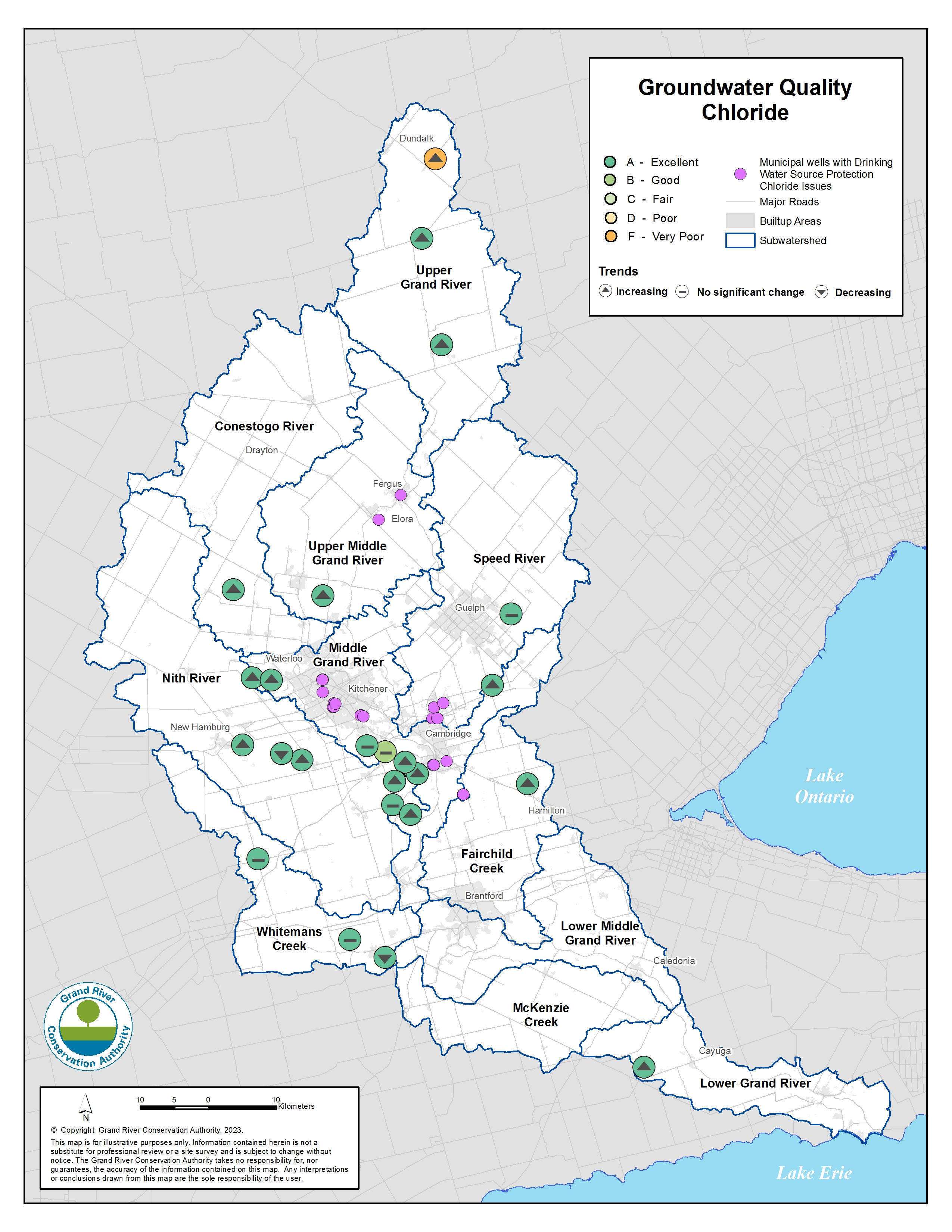
Groundwater quality
Groundwater is an important water source in the Grand River watershed. We monitor groundwater levels and quality in more than 50 wells. Thirty-eight of the wells are part of the Provincial Groundwater Monitoring Network. Learn more about how groundwater is used for drinking water in our watershed.
Chloride
Chloride can occur naturally in groundwater. Road salt and home water softeners can result in higher levels of chloride in groundwater. Too much chloride can affect human and animal health and damage vegetation, crops, and infrastructure.
- Most provincial wells received a grade of excellent (A). These wells are in rural areas and often have low chloride levels. Chloride levels in many of the wells are rising over time.
- Rising chloride levels are an issue for 28 municipal drinking water wells. These wells are in urban areas where road salt and water softeners are more prevalent. The Grand River Source Protection Plan policies help protect these wells from further impacts.
Nitrate and Nitrite
Nitrogen occurs naturally in rocks and groundwater. The forms of nitrogen found in water include nitrate and nitrite. Fertilizers, manure, and septic systems can often result in higher levels of nitrate and nitrite in groundwater. Too much nitrogen in untreated drinking water can affect human and animal health.
- Most provincial monitoring wells received an excellent (A) grade.
- Nitrate levels can be higher in rural areas where the use of fertilizer can affect groundwater quality if not properly managed.
- Rising nitrate levels are an issue for 19 municipal drinking water wells in Waterloo Region, Guelph, and Brant County. The Grand River Source Protection Plan policies help protect these wells from further impacts.
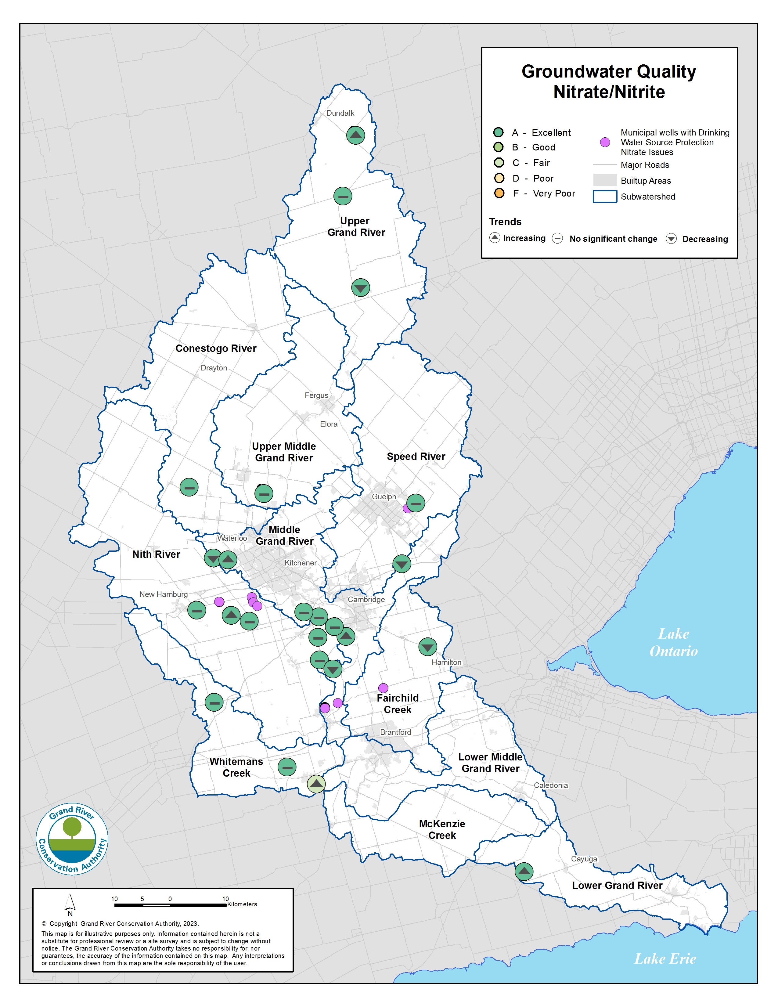
Groundwater quality Nitrate/Nitrite
Surface water quality
Our rivers, streams, and lakes provide many benefits:
- They are sources of water for human and animal consumption, irrigation, industry, and recreation.
- They receive treated effluent from 30 wastewater treatment plants.
- They are home to many fish and other aquatic plant and animal life.
We monitor surface water quality at many sites. Thirty-five sites are part of the Provincial Water Quality Monitoring Network. Phosphorus, chloride, and dissolved oxygen are important indicators of water quality.
Phosphorus
Phosphorus occurs naturally in small amounts but is also found in human and animal waste and fertilizers. Too much phosphorus in water can be harmful, causing algal blooms which reduce the oxygen available for fish.
Phosphorus levels have been improving over time, as outlined in the State of Water Resources (5MB PDF) report. Recent improvements are a result of the combined efforts of municipalities, farmers, the GRCA, and others.
- Phosphorus grades were generally fair (C) in the upstream areas of the Grand River and most of its tributaries. The Speed River received a grade of B, or good. Grades reflect conditions at the monitoring site furthest downstream in each watercourse.
- Phosphorus levels are higher further downstream. Lower grades are the result of runoff from urban and rural areas and treated effluent from wastewater treatment plants. Downstream areas and the Conestogo River received a grade of D, or poor. As the largest tributary of the eastern basin of Lake Erie, the Grand River is a major contributor of phosphorus to this body of water.
- The amount of phosphorus released from municipal wastewater treatment plants has been improving. Municipalities have made investments in new plant technologies. Many also take part in our optimization program to make the most efficient use of their equipment and people.
- Farmers and rural landowners are taking action to improve water quality. By planting trees and enhancing stream buffers, they help keep sediment and nutrients on their land and out of watercourses. The Rural Water Quality Program helps farmers with projects to protect water quality and build healthy soils.
Chloride
Road salt and home water softeners can result in higher levels of chloride in our streams. Too much chloride can affect human and animal health and damage vegetation, crops, and infrastructure.
- Chloride levels are below the federal guideline for protecting aquatic life from chronic impacts at most monitoring sites. Unfortunately, the creeks in some urban areas have levels that exceed the guidelines. Examples include sites on the lower Speed River, Schneider Creek, and Laurel Creek.
- Chloride levels have been increasing in the Speed and Grand rivers downstream of major urban areas since the 1970s.
Dissolved oxygen
Dissolved oxygen is an important measure of the Grand River's ability to support fish and other aquatic life.
- Dissolved oxygen levels in the river change throughout the day and are usually lowest in the early morning. If the levels drop too low, it can be harmful to fish and other organisms that live in the water.
- Dissolved oxygen levels have improved dramatically at some locations since the early 2000s. Investments in municipal wastewater treatment have played a key role. The State of Water Resources (5MB PDF) report shows how dissolved oxygen levels have improved.
Forest conditions
Forests help to clean our air and water, prevent erosion and flooding, and provide habitat for plants and animals. Forests help make our watershed more resilient in the face of climate change. The proportion of forest cover, interior forest cover, and riparian forest cover in each river basin determined the grades. Our Natural Heritage Characterization Reports include more information on forest conditions.
- Overall grades ranged from fair (C) to poor (D). Some areas scored higher for specific components. For example, the Speed River and McKenzie Creek basins scored higher for forest cover and riparian forest cover.
- Forest cover is generally low, especially in urban areas and productive farmlands. Forest cover ranges from 26% of the land area in the McKenzie Creek basin, to 11% of the land area in the Conestogo River basin.
- Larger forests often have a greater variety of plant and animal species, including those that are considered sensitive or rare. The term interior forest refers to the forest area that is more than 100 m from the forest edge. The McKenzie Creek basin has the most interior forest cover, while the Conestogo and Upper Middle Grand River basins have the least. Many forest patches throughout the watershed are small and isolated.
- Forest cover in riparian areas, the 30 m on either side of a watercourse or water body, is generally low. Riparian forests help protect water quality, provide habitat, and act as corridors for wildlife. Riparian forest cover is greatest in the Whitemans Creek, McKenzie Creek, and Speed River basins.
- You can help grow our forest cover by planting trees. Trees help protect soil and crops, buffer creeks from pollutants, create habitat for plants and animals, and clean air.
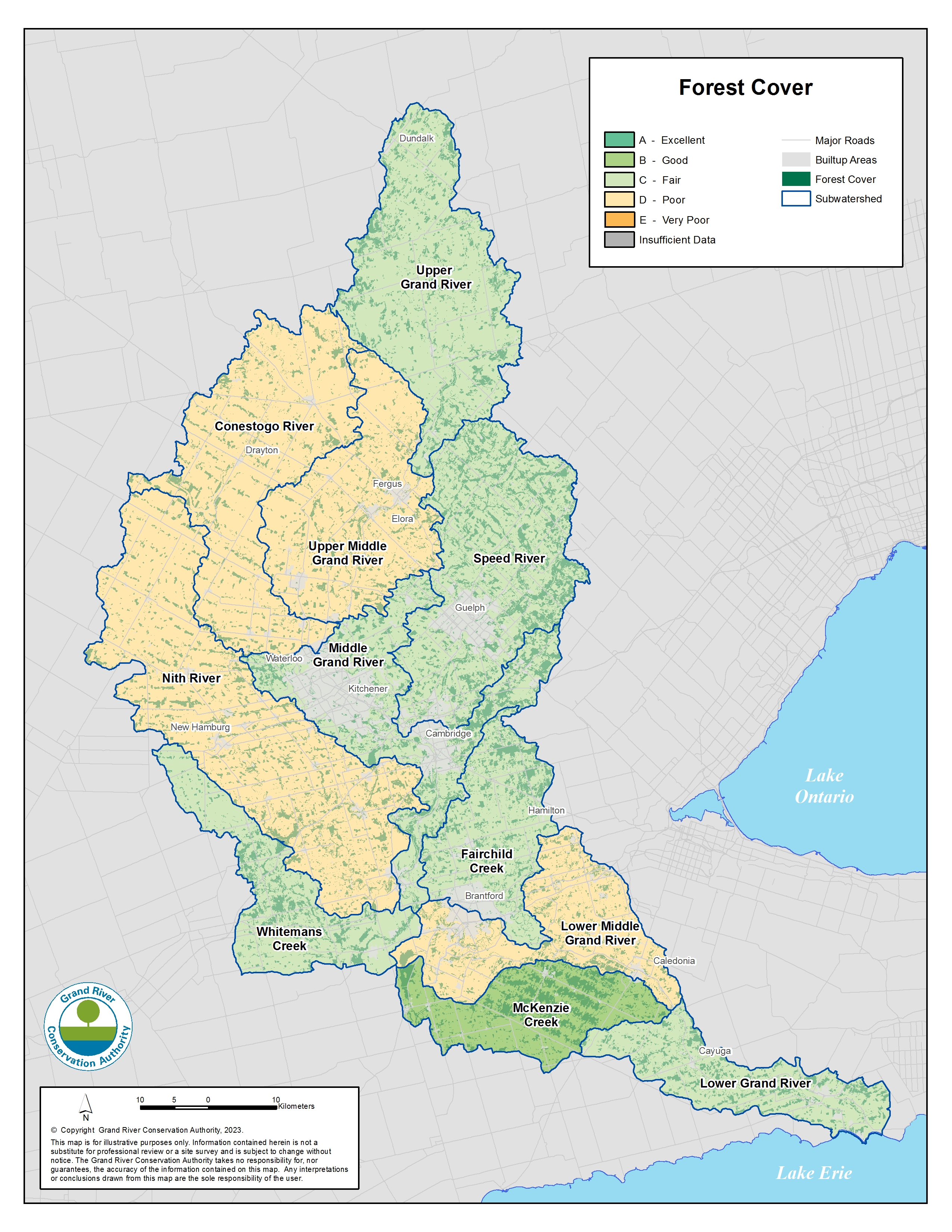
Forest cover
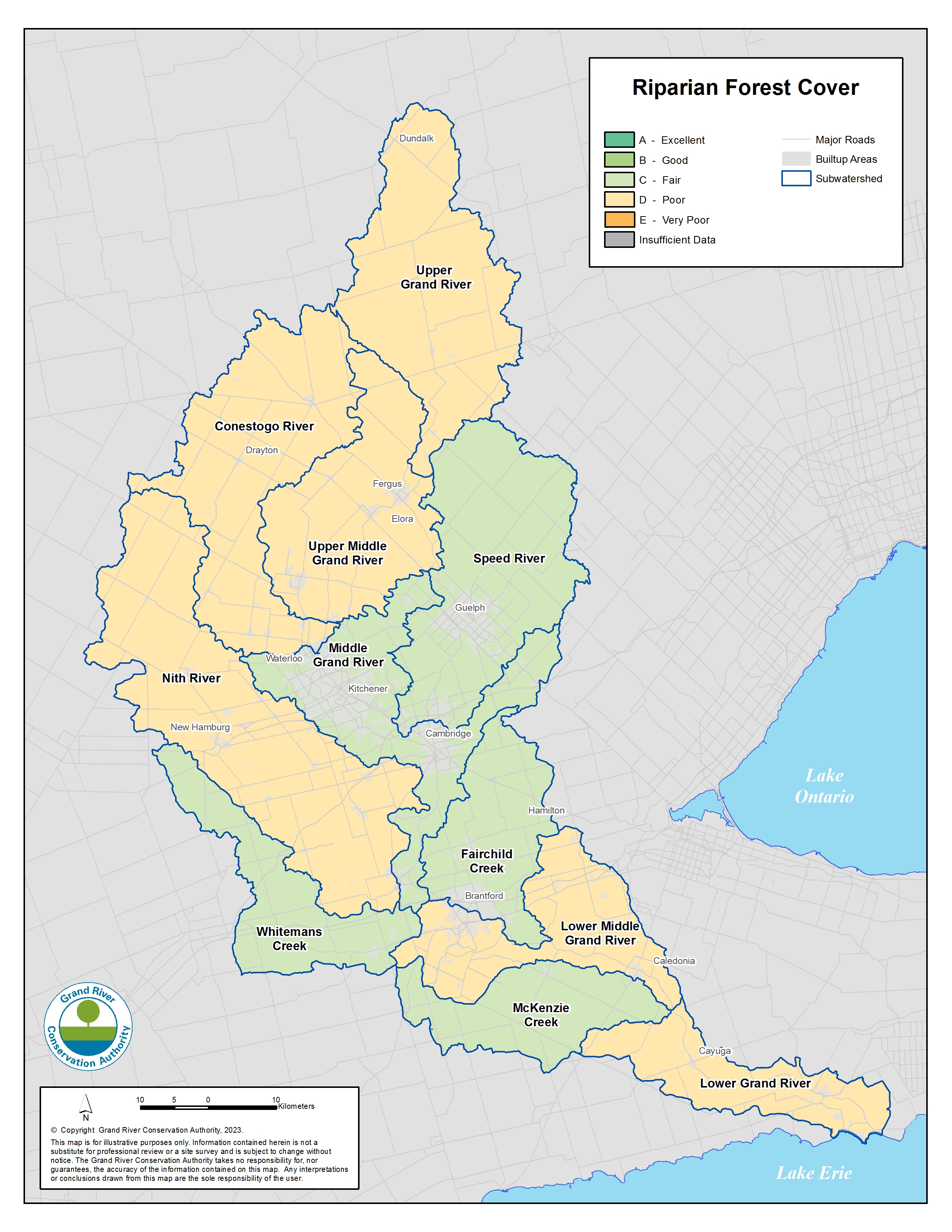
Riparian forest cover
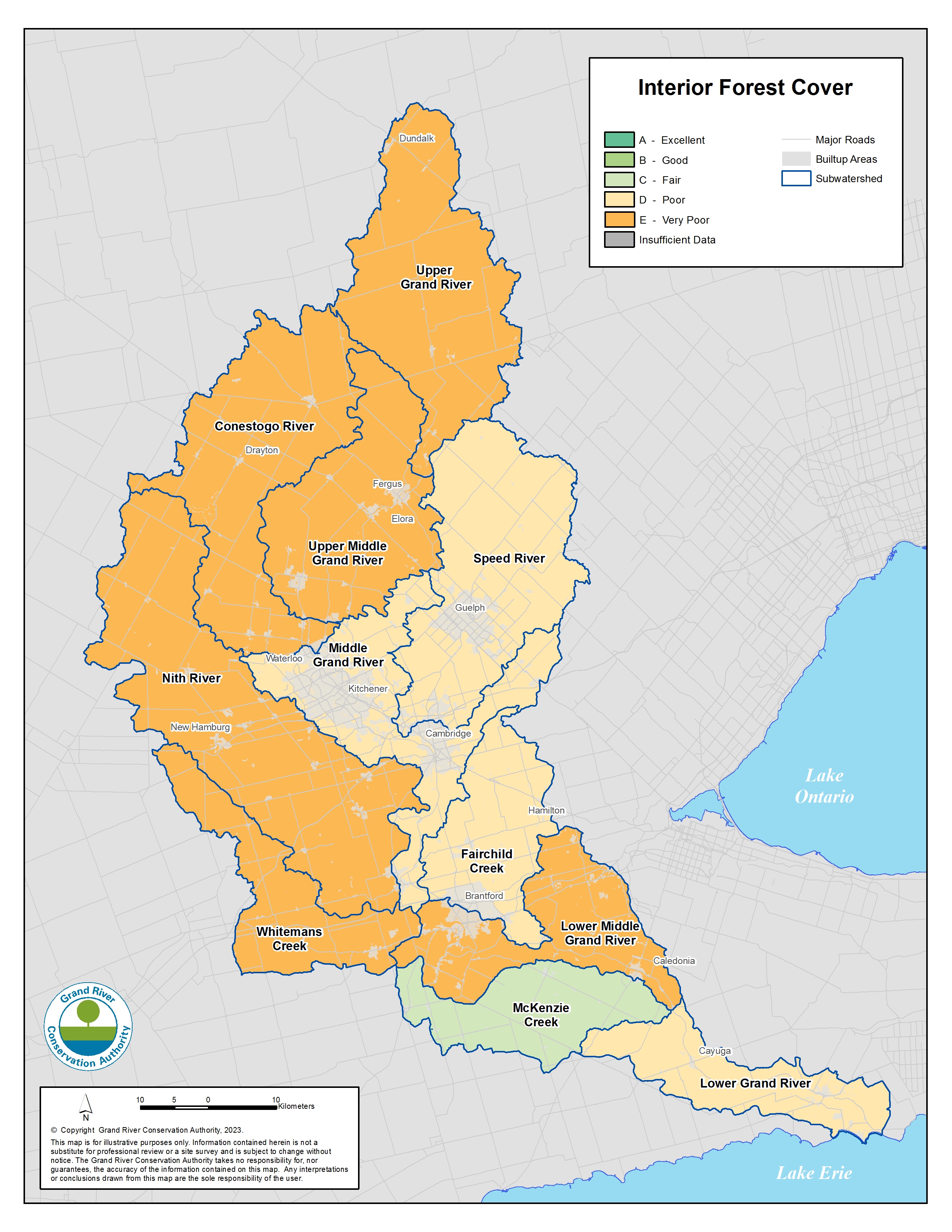
Interior forest cover
Wetland conditions
Wetlands are areas that are seasonally or permanently covered by shallow water or have groundwater close to the surface. Wetlands store and filter water and provide habitat for many plants and animals. By absorbing rain, wetlands help make our watershed more resilient to climate change. The proportion of wetland land cover in each river basin determined the grades. Our Natural Heritage Characterization Reports include more information on wetland conditions.
- Wetland cover grades ranged from excellent (A) to poor (D). The Upper Grand River, Speed River, and Whitemans Creek basins had the highest grades. The Conestogo River and lower Grand River basins had the lowest grades. Overall, wetlands cover about 10% of the watershed. While wetland mapping is incomplete in the McKenzie Creek basin, it is known to have many natural areas, including wetlands.
- All four types of wetlands are found in our watershed: swamps, marshes, bogs, and fens.
- Many wetlands are small and isolated, but remain important for habitat and water storage. Rivers, creeks, or other water bodies connect some smaller wetlands into larger wetlands. Smaller wetlands may be more vulnerable to adjacent land practices and development pressure.
- Larger wetlands still remain and make up a big proportion of wetlands in the Grand River watershed. Examples include Luther Marsh and Dunnville Marsh.
- All wetlands are part of the natural heritage system, which contributes to the overall health of the watershed.
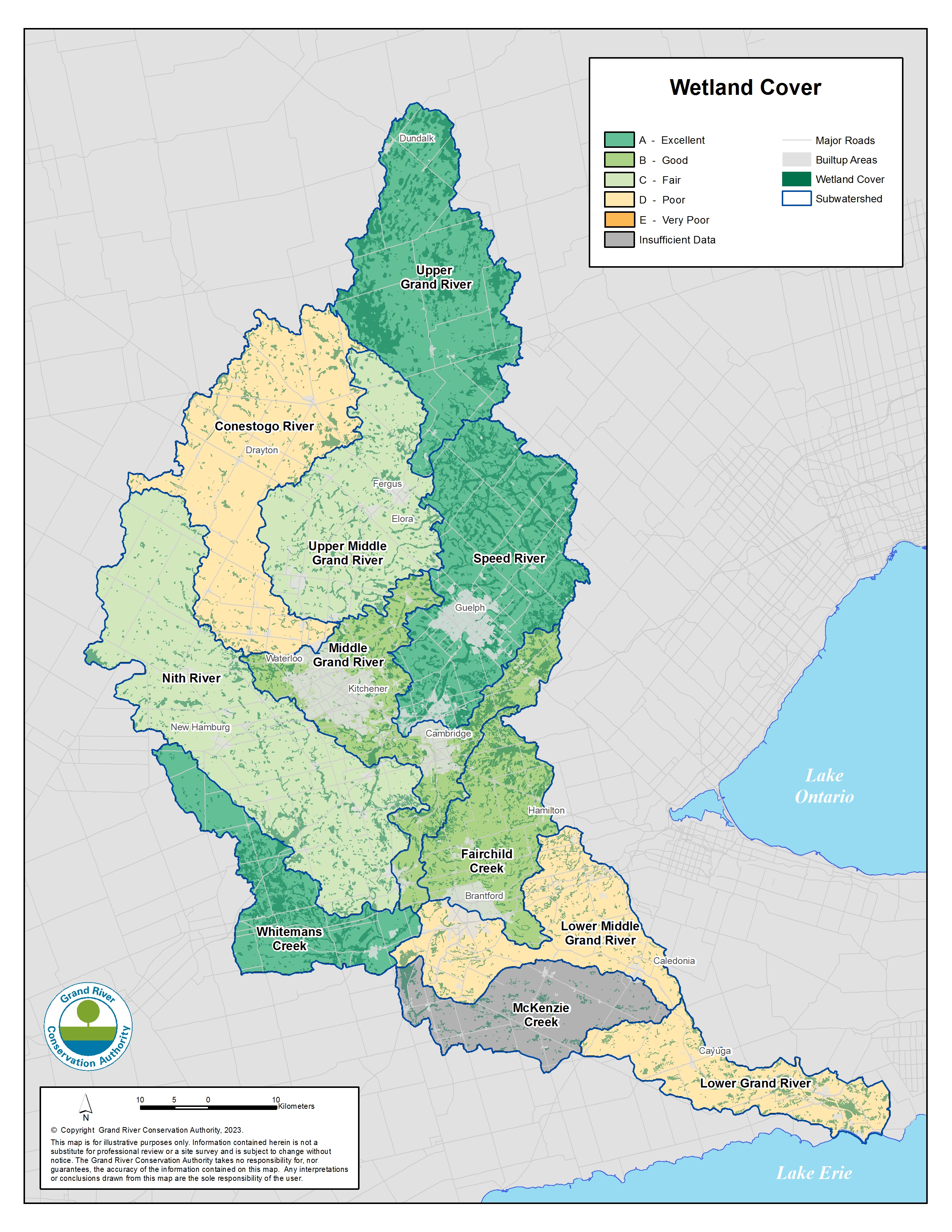
Wetland cover
Next Steps
Contact Us
Grand River Conservation Authority
400 Clyde Road, PO Box 729
Cambridge, ON
N1R 5W6
Phone: 519-621-2761
Toll Free: 1-866-900-4722
grca@grandriver.ca