
Nith River flows
- Learn how to read our River and stream flow charts, and our Reservoir charts.
- Many timeseries can be downloaded from our Data Downloads page.
Brochure
- Download a copy of the brochure Preparing for Flooding: A Guide for Residents of New Hamburg
- Download a copy of the brochure Preparing for Flooding: A Guide for Residents of Ayr
Critical flows
| Gauge (Community) | Flow (m3/s) | Significance |
|---|---|---|
| Nithburg | 0.2 | Normal summer low flow |
| 75 | Water at banks; low-lying areas flooded | |
| Phillipsburg | 0.6 | Normal summer low flow |
| 108 | Water at banks; low-lying areas flooded | |
| New Hamburg | 1.5 | Normal summer low flow |
| 120 | Water at banks | |
| 142 | Warning Zone 1; water on fairgrounds | |
| 175 | Warning Zone 2 | |
| 300 | Warning Zone 3 | |
| 500 | Warning Zone 4 | |
| Ayr | 2.6 | Normal summer low flow |
| 110 | Water at banks; low-lying areas flooded | |
| 142 | Water on parking lots behind Northumberland St. | |
| up to 200 | Warning Zone 1 | |
| 226 | Water at rear doors behind Northumberland St. | |
| 200 to 300 | Warning Zone 2 | |
| 300 to 400 | Warning Zone 3 | |
| 400 to 600 | Warning Zone 4 | |
| 600 to 800 | Warning Zone 5 | |
| Canning | 2.9 | Normal summer low flow |
| 120 | Water at banks; low-lying areas flooded |
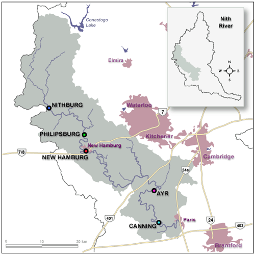
Location of flow gauges in the Nith River
Provisional Data
Caution: Users of the GRCA's real-time data are cautioned to consider the provisional nature of the information before using it for decisions that concern personal or public safety or the conduct of business.
The Grand River Conservation Authority assumes no responsibility for the correctness of the information contained in this website nor liability to any user of such information, regardless of the purpose.
Warning! River levels and flows can change rapidly.
Contact Us
Grand River Conservation Authority
400 Clyde Road, PO Box 729
Cambridge, ON
N1R 5W6
Phone: 519-621-2761
Toll Free: 1-866-900-4722
grca@grandriver.ca