Skip to main content Skip to footer

Natural Heritage Systems

What is natural heritage?

Natural heritage refers to wetlandsforests, river and creek valleys, hills and other natural features and functions in an area, as well as all the different plants and animals that use those areas. 

Natural heritage features provide many benefits, including habitat for plants and animals, erosion control, flood control, clean air, and clean water

What is a Natural Heritage System?

A natural heritage system is made up of natural heritage features and areas which are linked by natural corridors and which are necessary to maintain biological and geological diversity, natural functions, viable populations of indigenous species, and ecosystems. A natural heritage system can be thought of as a linked network of natural areas.

Maps can help us understand where these features and their functions are located. Maps can also show how these features are connected to each other and how they work together as one system. Maps can also identify the locations of environmentally significant areas and potential habitat restoration or enhancement areas. 

Natural Heritage Characterization Reports

We prepared Natural Heritage Characterization Reports to help identify the variety of natural heritage features and functions and to describe the complexity and importance of natural heritage systems across the Grand River watershed. The reports also help identify linkages between natural heritage features and areas, surface water features, and groundwater features.

The Characterization Reports use existing information from a variety of sources such as the Grand River Information Network. The reports provide information and mapping that will help us, and others, protect, restore and enhance natural heritage systems within 11 geographically distinct subwatersheds that make up the Grand River watershed.

watershed, or subwatershed, is defined as an area of land where all the surface water drains into the same place, whether it's a creek, a stream, or a river. At 6,800 square kilometres, the Grand River watershed is about the same size as the province of Prince Edward Island. Since the Grand River watershed is so large, there are many different natural heritage features and functions to describe, which makes for a very complex natural heritage system. 

Use the maps to help identify your municipality and your subwatershed. Then click on the subwatershed headings below to learn more about the natural heritage characteristics of your subwatershed.

First Map: Subwatershed areas in the Grand River watershed
Second Map: Municipal boundaries, major roads, rivers and cities in the Grand River watershed

Map of Grand River Subwatersheds
Map of Grand River Watershed

Overview

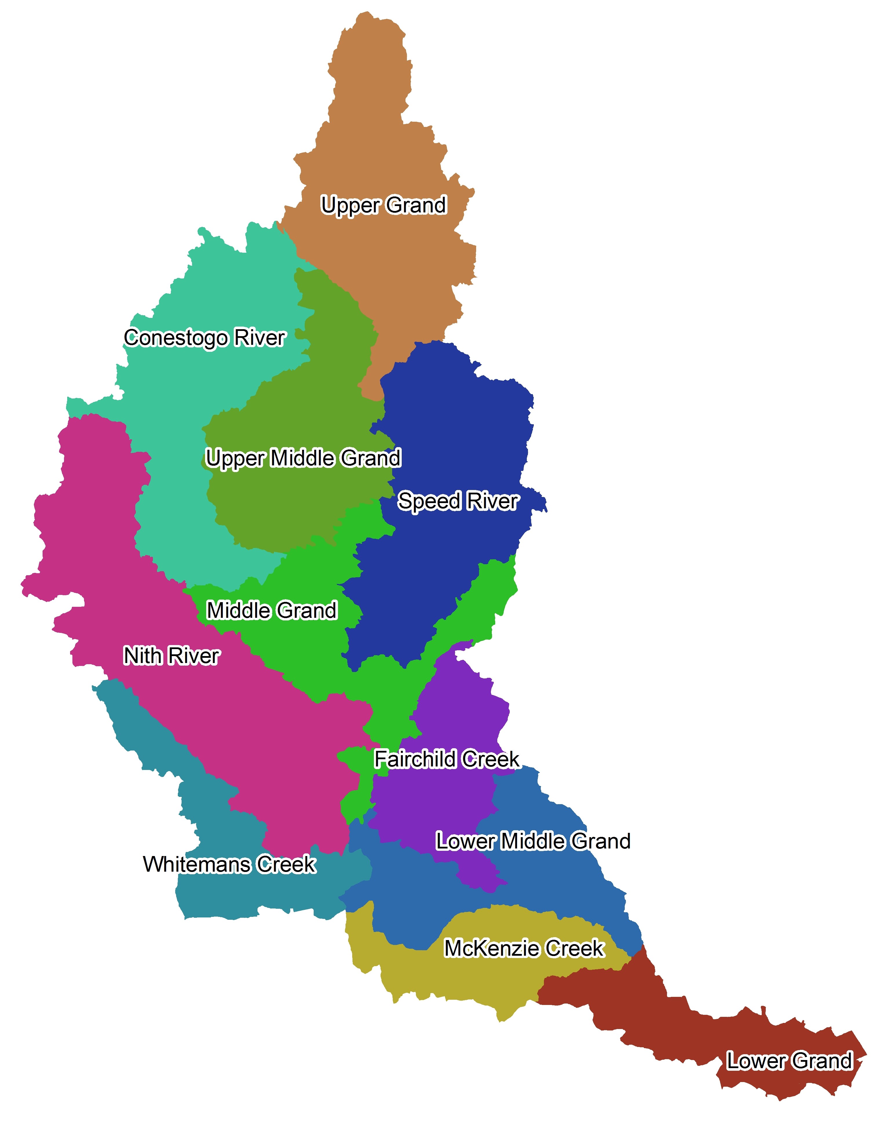
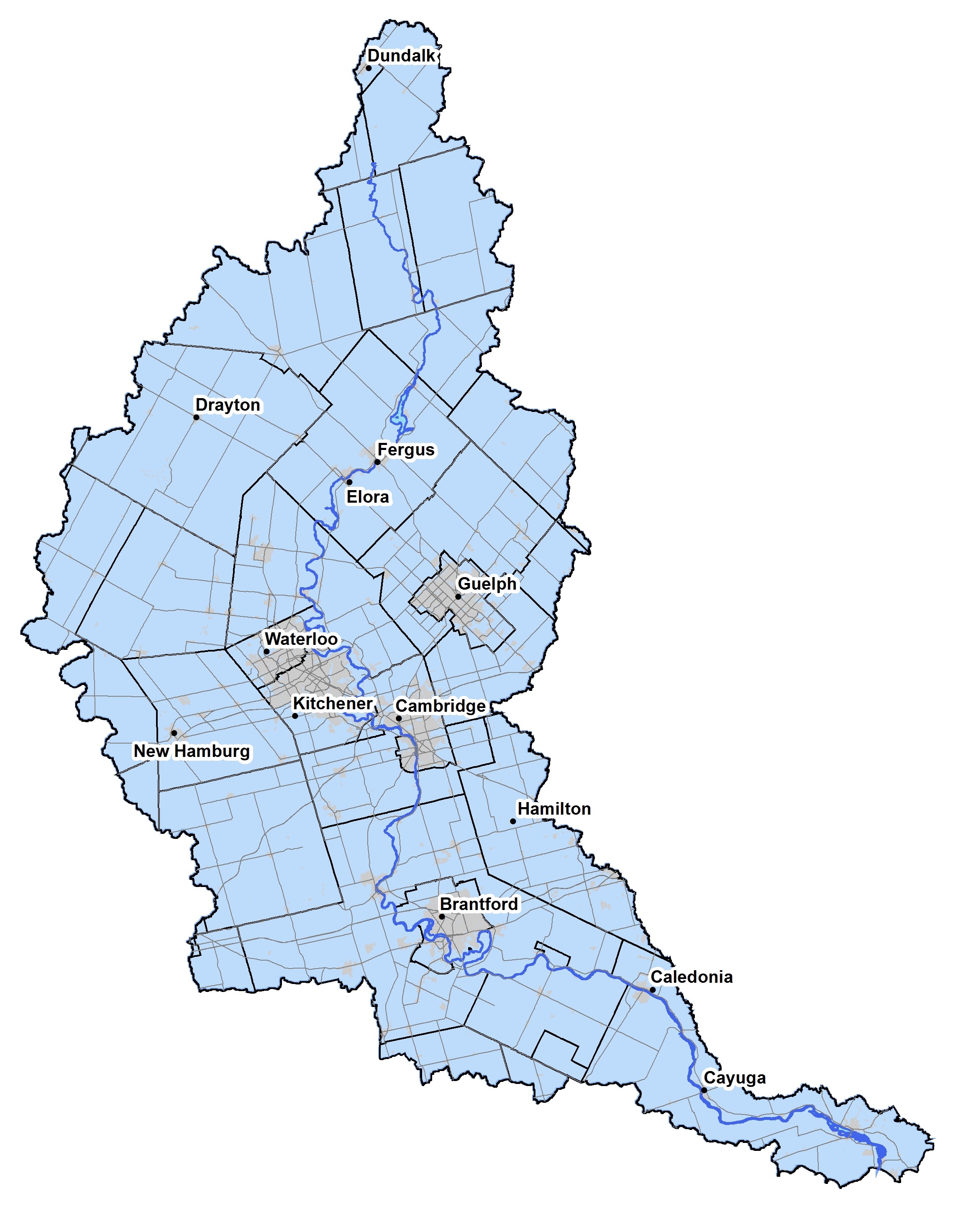
The Upper Grand River subwatershed is located in the most northern portion of the Grand River watershed. It is where the Grand river starts. The subwatershed comprises portions of the Townships of Amaranth, East Garafraxa, Grand Valley, Melancthon, Southgate, and Wellington North. The Grand River starts northeast of Dundalk. The southern most portion of the watershed is at the Shand Dam, at Belwood Lake. The subwatershed total area is 79,100 hectares or 12% of the Grand River watershed.

Land

  • Wetland area is 14,568 hectares or 18% of the subwatershed.
  • Woodland area is 12,158 hectares or 15% of the subwatershed.
  • There are four distinct physiographic regions: the Dundalk Till Plain, Stratford Till Plain, Hillsburgh Sandhills, and the Guelph Drumlin Field.
  • There are 7 areas of natural scientific interest.

Water

  • Total watercourse length is 1,128 kilometres.
  • Total cold water stream length is 50 kilometres.
  • Luther Lake and Belwood Lake are the largest lakes in the subwatershed. They are both reservoirs used by the GRCA for flood management

Plants and Animals

  • 34 fish species have been recorded in the subwatershed.
  • 6 mussel species have been recorded in the subwatershed.
  • Two invasive aquatic species, the rusty crayfish and the round goby, have been detected at Belwood Lake. 
  • 38 provincially significant species have been recorded in the subwatershed.
  • Some examples of species at risk that have been recorded in the subwatershed include Henslow's sparrow, loggerhead shrike, Butler's gartersnake, and spotted turtle.

Overview

The Conestogo River subwatershed is located within the north-west portion of the Grand River watershed. The Conestogo River starts in the Damscus-Kennilworth area of the Township of Wellington North and flows through the towns of Glen Allan, Wallenstein, Hawkesville, and St. Jacobs before joining the Grand River in the Village of Conestogo. Subwatershed total area is 82,000 hectares or 12% of the Grand River watershed.

Land

  • Wetland area is 3,750 hectares or 5% of the subwatershed.
  • Woodland area is 8,615 hectares or 11% of the subwatershed.
  • There are three distinct physiographic regions: the Dundalk Till Plain and Stratford Till Plan, plus the northern flank of the Waterloo Moraine.
  • There are 12 areas of natural scientific interest.

Water

  • Total watercourse length is 1,409 kilometres.
  • Total cold water stream length is 1 kilometre.
  • Conestogo Lake is a flood management reservoir managed by the GRCA.
  • Conestogo Lake represents the midway point of the river system and partially regulates flows in the lower reaches.

Plants and Animals

  • 46 fish species have been recorded in the subwatershed.
  • 13 mussel species have been recorded in the subwatershed.
  • 29 provincially significant species have been recorded in the subwatershed.
  • Some examples of species at risk that have been recorded in the subwatershed include butternut, cerulean warbler, red knot, and loggerhead shrike.

Overview

The Upper Middle Grand River subwatershed includes sections of Mapleton, Wellington North, Centre Wellington, and Guelph-Eramosa Townships in the County of Wellington; a small section of the Town of Grand Valley in Dufferin County; and the northern half of Woolwich Township in the Region of Waterloo. Subwatershed total area is 64,000 hectares or 9% of the Grand River watershed.

Land

  • Wetland area is 4,593 hectares or 7% of the subwatershed.
  • Woodland area is 7,557 hectares or 12% of the subwatershed.
  • There are four distinct physiographic reigons: the Stratford Till Plain, Guelph Dumlin Field, Oxford Till Plain, and the Dundalk Till Plain.
  • There are 7 areas of natural scientific interest.

Water

  • Total watercourse length is 927 kilometres.
  • Total cold water stream length is 164 kilometres.
  • Woolwich reservoir is the largest lake in the subwatershed. The reservoir is managed by the GRCA for flood management.

Plants and Animals

  • 34 fish species have been recorded in the subwatershed.
  • 6 mussel species have been recorded in the subwatershed.
  • Brown trout has been introduced into the Grand River downstream of Shand Dam. This species supports a world class trout fishery in this portion of the Grand River.
  • 29 provincially significant species have been recorded in the subwatershed.
  • Some examples of species at risk that have been recorded in the subwatershed include American ginseng, monarch, redside dace, and wavy-rayed lampmussel.

Overview

The Speed River subwatershed drains eastern portions of the City of Cambridge, portions of the Town of Erin, Townships of Centre Wellington and Puslinch, the City of Guelph, a small portion of the Town of Milton, and the southern tip of the Township of East Garafraxa. Subwatershed total area is 78,000 hectares or 12% of the Grand River watershed.

Land

  • Wetland area is 13,523 hectares or 17% of the subwatershed.
  • Woodland area is 18,546 hectares or 24% of the subwatershed.
  • There are three distinct physiographic reigons, the Guelph Drumlin Field, the Paris-Galt Moraine, and a small portion of the Orangeville Moraine.
  • Fractured bedrock at the ground surface and unique, karst features such as caves and potholes are located within the Rockwood area. 
  • There are 23 areas of natural scientific interest.

Water

  • Total watercourse length is 1,039 kilometres.
  • Total cold water stream length is 276 kilometres.
  • Two major rivers, the Speed and the Eramosa, flow in a southwesterly direction through the subwatershed.
  • Major tributaries of the Eramosa River, which joins the Speed River in the City of Guelph, include Blue Springs Creek and Clythe Creek.
  • Guelph Lake is the largest lake in the subwatershed.  It is a reservoir that is managed by the GRCA for flood management.

Plants and Animals

  • 40 fish species have been recorded in the subwatershed.
  • 11 mussel species have been recorded in the subwatershed.
  • 50 provincially significant species have been recorded in the subwatershed.
  • Some examples of species at risk that have been recorded in the subwatershed include American ginseng, golden eagle, Jefferson salamander, and silver shiner.

Overview

The subwatershed includes portions of the Townships of Mapleton, Wellesley, Wilmot, and North Dumfries, Perth East, Blandford-Blenheim, and a small portion of Brant County. A very small portion of the west side of Kitchener is contained within this subwatershed. The subwatershed contains smaller portions of the City of Waterloo and the City of Cambridge, which are mostly located to the east. The start of the Nith River is located in Mapleton Township at the extreme north end of the subwatershed. The river flows in a southeasterly direction and joins the Grand River in the Town of Paris. Subwatershed total area is 112,800 hectares or 17% of the Grand River watershed.

Land

  • Wetland area is 6,481 hectares or 6% of the subwatershed.
  • Woodland area is 14,559 hectares or 13% of the subwatershed.
  • There are three distinct physiographic regions, Stratford Till Plains, Waterloo Hills, and the Horseshoe Moraines. 
  • There are 28 areas of natural scientific interest.

Water

  • Total watercourse length is 1,680 kilometres.
  • Total cold water stream length is 17 kilometres.

Plants and Animals

  • 60 fish species have been recorded in the subwatershed.
  • 18 mussel species have been recorded in the subwatershed.
  • 50 provincially significant species have been recorded in the subwatershed.
  • Some examples of species at risk that have been recorded in the subwatershed include American chestnut, queensnake, yellow-breasted chat, and kidneyshell.

Overview

The Middle Grand River subwatershed is located within the central portion of the Grand River watershed and contains large portions of the Cities of Waterloo, Kitchener, and Cambridge, as well as portions of the Townships of Puslinch, Guelph Eramosa, North Dumfries, County of Brant, and small corner of the City of Brantford. The subwatershed is subject to a great amount of development pressure. Subwatershed total area is 60,400 hectares or 9% of the Grand River watershed.

Land

  • Wetland area is 6,428 hectares or 11% of the subwatershed.
  • Woodland area is 11,351 hectares or 19% of the subwatershed.
  • There are four distinct physiographic regions, Waterloo Hills, Horeshoe Moraines, Guelph Drumlin Field, 
  • There are 12 areas of natural scientific interest.

Water

  • Total watercourse length is 722 kilometres.
  • Total cold water stream length is 9 kilometres.

Plants and Animals

  • 56 fish species have been recorded in the subwatershed.
  • 14 mussel species have been recorded in the subwatershed.
  • 82 provincially significant species have been recorded in the subwatershed.
  • Some examples of species at risk that have been recorded in the subwatershed include American colombo, Acadian flycatcher, monarch, American badger, queensnake, and rainbow mussel.

Overview

Fairchild Creek subwatershed is located within the east central portion of the Grand River watershed and contains sections of the City of Hamilton and Brant County. Fairchild Creek flows southwest from Puslinch Township and then southeast before joining the Grand River near the Village of Onandaga. Subwatershed total area is 40,100 hectares or 6% of the Grand River watershed.

Land

  • Wetland area is 4,245 hectares or 11% of the subwatershed.
  • Woodland area is 7,820 hectares or 20% of the subwatershed.
  • There are four distinct physiographic regions, Horseshoe moraines, Flamborough plain, Norfolk sand plain, and the Haldimand clay plain.
  • There are 2 areas of natural scientific interest.

Water

  • Total watercourse length is 981 kilometres.
  • Total cold water stream length is 24 kilometres.
  • Major tributaries include Barlow Creek and Big Creek.

Plants and Animals

  • 47 fish species have been recorded in the subwatershed.
  • 12 mussel species have been recorded in the subwatershed.
  • 99 provincially significant species have been recorded in the subwatershed.
  • Some examples of species at risk that have been recorded in the subwatershed include king rail, American chestnut, Jefferson salamander, little brown bat, eastern sand darter, and round pigtoe.

Overview

Whitemans Creek subwatershed drains portions of Perth County, Oxford County, and Brant County. Whitemans Creek has 2 main branches: Horner Creek, which flows south through Blandford-Blenheim Township, and Kenny Creek, which flows south through Norwich Township in Oxford County and eastward through Brant County. The confluence of these 2 main branches represents the beginning of Whitemans Creek, which enters the Grand River 5 km upstream of the City of Brantford. Subwatershed total area is 64,000 hectares or 9% of the Grand River watershed.

Land

  • Wetland area is 5,412 hectares or 13% of the subwatershed.
  • Woodland area is 6,819 hectares or 17% of the subwatershed.
  • There are 5 distinct physiographic regions, the Stratford Till Plain, Oxford Till Plain, Mount Elgin Ridges, Norfolk Sand Plain, and the Horseshoe Moraines.
  • There are 8 areas of natural scientific interest.

Water

  • Total watercourse length is 521 kilometres.
  • Total cold water stream length is 27 kilometres.

Plants and Animals

  • 41 fish species have been recorded in the subwatershed.
  • 7 mussel species have been recorded in the subwatershed.
  • 32 provincially significant species have been recorded in the subwatershed.
  • Some examples of species at risk that have been recorded in the subwatershed include large whorled pogonia, eastern hog-nosed snake, and prothonotary warbler.

Overview

The Lower Middle Grand River subwatershed captures middle portions of the Grand River watershed, including portions of the City of Hamilton, City of Brantford, Brant and Haldimand Counties, and the Six Nations of the Grand River lands. The subwatershed includes the section of the Grand River between the mouth of the Nith River in Paris to the Village of York in Haldimand County. Subwatershed total area is 47,600 hectares or 7% of the Grand River watershed.

Land

  • Wetland area is 1,895 hectares or 4% of the subwatershed.
  • Woodland area is 6,860 hectares or 14% of the subwateshed.
  • The subwatershed is characterized largely as agricultural with a small section of urban land use in the City of Brantford.
  • There are 3 distinct physiographic regions, the Haldimand Clay Plain, the Norfolk Sand Plain, and the Galt-Paris Moraine.
  • There are 5 areas of natural scientific interest.

Water

  • Total watercourse length is 1,343 kilometres.
  • Total cold water stream length is 54 kilometres.
  • Significant tributaries of the Grand River include Fairchild Creek and Whitemans Creek.

Plants and Animals

  • 65 fish species are found in the subwatershed, including Brook trout found in Mount Pleasent and D'Aubigny Creeks.
  • 25 mussel species have been recorded in the subwatershed.
  • 106 provincially significant species have been recorded in the subwatershed.
  • Some examples of species at risk that have been recorded in the subwatershed include American colombo, Acardian flycatcher, cerulean warbler, American badger, Jefferson's salamander, queensnake, eastern sand darter, and kidneyshell.

Overview

The McKenzie Creek subwatershed is located within the central portion of the Grand River watershed. The creek system includes a north branch (McKenzie Creek), which originates in the Oakland Swamp, and a south branch (Boston Creek), which originates on the Norfolk Sand Plain. The subwatershed drains portions of Brant, Haldimand, and Norfolk Counties as well as large portions of 2 First Nations Territories: Six Nations of the Grand River and Mississaugas of the Credit First Nation. Surface flows are generally eastward toward the Grand River in the Village of York. Subwatershed total area is 36,800 hectares or 5% of the Grand River watershed.

Land

  • Wetland area is 1,351 hectares or 4% of the subwatershed.
  • Woodland area is 9,667 hectares or 26% of the subwateshed.
  • There are 3 area of natural scientific interest.

Water

  • Total watercourse length is 616 kilometres.
  • 0 kilometres are classified as cold water stream.
  • 501 kilometres are not classified.

Plants and Animals

  • 55 fish species have been recorded in the subwatershed.
  • 22 mussel species have been recorded in the subwatershed.
  • 63 provincially significant species have been recorded in the subwatershed.
  • Some examples of species at risk that have been recorded in the subwatershed include eastern flowering dogwood, gray ratsnake, barn owl, American badger, and eastern pondmussel.

Overview

The Lower Grand River subwatershed is located at the southern end of the watershed and is situated almost entirely within Haldimand County. This subwatershed drains a very small area of the Six Nations of the Grand River lands. This subwatershed includes the section of the Grand River between York and the river mouth, which is located at Port Maitland on the Lake Erie shoreline. Subwatershed total area is 35,600 hectares or 5% of the Grand River watershed

Land

  • Wetland area is 1,805 hectares or 5% of the subwatershed.
  • Woodland area is 6,960 hectares or 20% of the subwateshed.
  • Agricultural lands account for 65-75% of the land area. 
  • There is one distinct physiographic region, the Haldimand Clay Plain.
  • There are 12 areas of natural scientific interest.

Water

  • Total watercourse length is 820 kilometres.
  • 0 kilometres are classified as cold water stream.
  • 616 kilometres are not classified.

Plants and Animals

  • 80 fish species have been recorded in the subwatershed.
  • 32 mussel species have been recorded in the subwatershed.
  • 87 provincially significant species have been recorded in the subwatershed.
  • Some examples of species at risk that have been recorded in the subwatershed include virginia mallow, king rail, American badger, Fowler's toad, eastern sand darter, and lilliput mussel.

Full characterization reports

Full characterization reports for each subwatershed are available (PDFs). Please email the Natural Heritage department.

This website uses cookies to enhance usability and provide you with a more personal experience. By using this website, you agree to our use of cookies as explained on our Privacy page.