Ice Jams
The presence of ice in a river or stream can create special problems.
The ice can interfere with the operation of flow gauges and sometimes causes false readings.
Even more important, though, is that ice can sometimes pile up in a location and create an "ice jam". Water will back up behind the jam and can cause water to spill out of the river and flood surrounding areas.
Ice jams tend to form in places where a river is shallow, or where it goes through twists and turns. Communities with a history of ice jam flooding include Grand Valley, Drayton, West Montrose, New Hamburg, Ayr, Wolverton, Cambridge, Paris, Brantford, Cayuga and Dunnville.
Some of the most serious flooding in those communities has happened because of ice jams. Flooding can occur even at relatively low flows. Jams can set up in minutes, so there may be little or no time to issue warnings.
That's why it's important for residents and emergency services to be on guard in places where ice jams are possible.
Spotting an ice jam on the flow charts

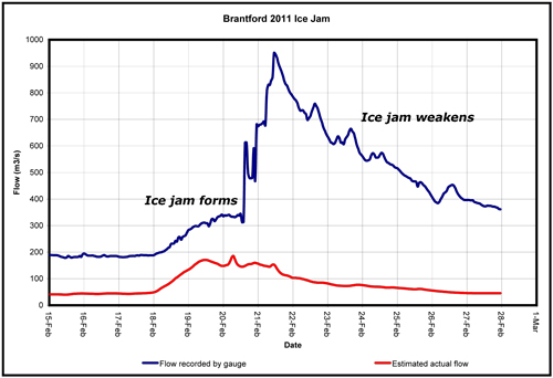
Ice jams show up on river flow charts as a sudden spike as the ice jam forms. After that, the ice jam may settle in place and the measured flow rate will stay at the elevated level.
Sometimes, the ice jam will begin to weaken and water will start to make its way through. Then the flow line on the graph will start to drop.
This chart shows an ice jam that formed at Brantford in February 2011.
- The blue line (the topmost line) shows the water level as recorded by the gauge in Brantford. The ice jam was strong enough to cause minor flooding in the area and a road closure.
- Over the next couple of days the jam weakened and the measured water levels dropped.
- The red line (the line on bottom) shows what the flows would have been like in open water conditions, without an ice jam.
Contact Us
Grand River Conservation Authority
400 Clyde Road, PO Box 729
Cambridge, ON
N1R 5W6
Phone: 519-621-2761
Toll Free: 1-866-900-4722
grca@grandriver.ca
