Skip to main content Skip to footer

Record rainfall flood June 2017

What caused the flooding? 

The flooding associated with the June 23, 2017 record rainfall event was the direct result of more than 100 mm of rain falling in the span of two to three hours across a wide section of the northern portion of our watershed. 


Rainfall radar image from June 23, 2017

Rain gauges at Luther Marsh indicated that this was the highest recorded one-day total rainfall for that area since record-keeping began in 1950. 

This is an unprecedented volume of rainfall at any time of year, let alone in such a condensed time period, over a relatively large area during the summer. 

The rainfall that occurred during this event was not identified in any weather forecasts in advance of the event. Environment Canada did identify a chance of localized, severe thunderstorms in a message put out shortly before midnight on June 22, 2017, but there was no indication that any of those storms would contain rainfall of this magnitude over such a widespread area. The original forecast on the afternoon of June 22 was for 5 to 10 mm of rainfall over areas of the watershed on June 23, 2017.

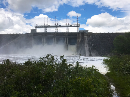
We operate a sophisticated series of rainfall and river flow gauges throughout the watershed. These gauges are designed to alert staff on-duty 24-hours a day in the event that river flows increase quickly, or heavy rainfall occurs.

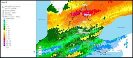
As a result of the heavy rainfall that occurred on June 23, the following actions occurred.

Summary of actions

Time Action
3:13a.m.
  • Duty officer received voice alarm indicating 25 mm of rainfall had fallen at Luther Marsh rainfall gauge station and notified the senior dam operator

4:17a.m.
  • Senior dam operator dispatched dam operators to attend major water control structures

5:40a.m.
  • We opened flood operations centre and began notifying municipal flood coordinators in the northern Grand River watershed of significant rainfall and flooding

  • Municipal flood coordinators began notifying residents and closing roads at risk of flooding

9:15a.m.
  • Our staff completed an assessment of flooding forecast and issued Flood Message #1, warning all townships and municipalities north of Cambridge that were at risk of flooding

A series of seven additional flood warning messages were subsequently issued between June 23 and June 27, 2017. These flood messages provided actions and updates to municipal flood coordinators, emergency services and municipal staff as the event unfolded.

The same messages were also immediately posted to our website and social media feeds, emailed directly to newsroom subscribers, and sent out to all local media outlets.


What do our reservoirs do?

Shand Dam at 60 cubic metres per second

Our major reservoirs serve two purposes: 

  1. They work as a system to provide maximum flood control when it is needed most (in the spring, to reduce downstream impact of snow melt, and fall, to handle the remnants of tropical hurricanes).
  2. They provide flow augmentation to the river during the dry summer months. Flow augmentation helps ensure there is enough water downstream to support drinking water and wastewater treatment facilities.  

How did our reservoirs help with this event?

At this time of year, our reservoirs are approximately 90-96% full to support river flow augmentation. This provides up to 10% of reservoir capacity for flood storage. This additional storage space helped delay peak flows downstream by approximately 2 hours.


Where significant rainfall events are forecast days in advance, water levels in our reservoirs may be drawn down when possible, to help provide additional flood storage capacity. However, there was no advance warning of the significance of this event, and therefore no opportunity to proactively reduce water levels in our reservoirs.

  • Our reservoirs were operated following standard operational procedures in order to protect the integrity of the dams themselves.
  • Once flood storage capacity was reached, discharge from the dams was gradually adjusted to match flows in the river upstream of reservoirs. As soon as flows into the reservoirs began to decrease, so too did discharge from those reservoirs.
  • Maximum discharge from our dams does not exceed maximum flow into the reservoirs - this is to ensure that downstream flooding is not made worse due to the presence of these major dams.

Each flooding event is a learning opportunity for our staff, emergency services and municipal flood coordinators throughout the watershed.

As with any significant flood, staff meet with municipalities, emergency services, flood coordinators, businesses and residents. From these meetings, improvements to warning systems may be established allowing all agencies to be even more prepared for future flooding events.

  • Our staff met with the community of West Montrose on July 24, 2017 to present an overview of the cause and impact of the flooding that occurred as a result of the June 23 flood event.
  • Download a copy of the debriefing of the June 23, 2017 event (3.1MB PDF). (Please note this document may not be accessible to people with disabilities. If you have a disability and require a document in an alternate format, please contact us.)

This website uses cookies to enhance usability and provide you with a more personal experience. By using this website, you agree to our use of cookies as explained on our Privacy page.