Skip to main content Skip to footer

Bridgeport Dike Rehabilitation Project

Bridgeport Dike Rehabilitation and Capacity Improvement Class Environmental Assessment - Study Overview

The Grand River Conservation Authority (GRCA) and the City of Kitchener are undertaking the Bridgeport Dike Rehabilitation and Capacity Improvement Project Class Environmental Assessment and Preliminary Design Study. This study is funded in part by the Government of Canada as part of the Disaster Mitigation and Adaptation Fund (DMAF) and is being undertaken in partnership with the City of Kitchener. 

The GRCA has retained KGS Group to carry out the study. The intent of the study is to explore options to rehabilitate the existing Bridgeport Dike to meet the current and applicable standards, with consideration of public safety, the environment, cost, constructability, functionality and potential impacts to adjacent properties.

The study will follow the Conservation Ontario Class Environmental Assessment for Remedial Flood and Erosion Control Projects (Conservation Ontario 2002, amended 2013) to determine the best-suited remediation strategy for the Bridgeport Dike.

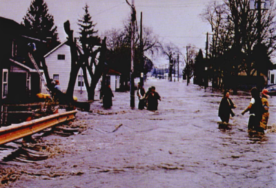
The community of Bridgeport is located along the bend of the Grand River in the City of Kitchener. The former village has a history of flooding, with serious flooding reported in 1948, 1954 and 1974, when the 1950s-era earth fill dike was overtopped.

The current 1.5 km-long dike extends along the east bank of the Grand River from upstream of the Bridge Street crossing.

  • The dike follows the riverbank until it turns inland, ending at Bridge Street past Schweitzer Street.
  • The dike protects a mix of residential, commercial, industrial and recreational lands.
  • There are municipal parks and sports fields on either side of the dike, and a trail running along the top of the dike. The sports fields behind the dike were designed to function as a stormwater detention facility to temporarily hold runoff from the lands behind the dike following a storm event.
  • There are approximately 100 residential, 24 industrial, and 3 institutional buildings within the diked area.
  • The original earthen dike was raised in 1980 to provide further protection from flood flows in the Grand River.

Recent studies have identified that the water levels in the Grand River would overtop parts of the dike if we were to experience flood flows that would be caused by a storm event of the same magnitude as Hurricane Hazel, which is the Regulatory Flood Event in this location. These recent engineering studies also determined that the current dike condition does not meet the design standards that are required to ensure that the dike will remain stable during the Regulatory Flood Event.

Aerial photo showing inundation of Bridgeport during flood of 1974 Residents standing in flooded street in residential area, Bridgeport, during flood of 1974

The objectives of the study are to:

  1. Assess the current conditions of the Bridgeport Dike and associated drainage outlets.
  2. Determine preferred approaches to Bridgeport Dike maintenance work. Maintenance will include:
    • Improving dike stability by mitigating seepage through and under the dike.

    • Replacing stormwater and drainage outlets through the dike.

    • Improving gauge stations. 

  3. Develop a list of potential alternatives for improving the capacity of the Bridgeport Dike to provide flood protection for the Regulatory Flood Event (Hurricane Hazel);
  4. Select the preferred alternative or alternatives based on environmental, social, economic and operational considerations.
  5. Consult the public and First Nations at key times throughout the study to solicit and incorporate public and First Nations input to be received in the decision-making process.

The Bridgeport Dike project is funded in part by the Government of Canada as part of the Disaster Mitigation and Adaptation Fund (DMAF) and is being undertaken in partnership with the City of Kitchener.

This study, which is the first phase of the entire Bridgeport Dike Rehabilitation and Capacity Improvement DMAF project, was initiated in late 2021 and will be completed over the course of two years. This study will cover consultation and preliminary design solutions for the dike capacity improvement. Final design and construction will be carried out as subsequent projects within the timelines of the DMAF grant application. Consultation and engagement for final design and construction of the preferred alternative or alternatives would be completed as part of those projects, and is not included within the scope of this current study.

Learn more about other Disaster Mitigation and Adaptation Fund projects by the City of Kitchener.

Government of Canada LogoCity of Kitchener Logo

A key component of the study is consultation with interested stakeholders (public, landowners and agencies) and First Nations. The intent of this study is to explore options to rehabilitate the existing Bridgeport Dike to meet the current and applicable standards, with consideration of public safety, the environment, cost, constructability, functionality and potential impacts to adjacent properties.

The GRCA hosted the first Public Information Centre related to this study on July 27, 2022.

Dates of future PICs will be posted on this page when available. 

This website uses cookies to enhance usability and provide you with a more personal experience. By using this website, you agree to our use of cookies as explained on our Privacy page.